|
COPERNICUS
According
to their website, Copernicus is a European system for monitoring
Planet
Earth.
Copernicus consists of a complex set of systems which collect data from multiple sources: earth observation
satellites and in situ sensors such as ground stations, airborne and sea-borne sensors. It processes these data
streams and provides users with reliable and up-to-date information through a set of services related to environmental and
security issues.
The services address six thematic areas: land, marine, atmosphere, climate change, emergency management and security. They support a wide range of applications, including environment protection, management of urban areas, regional and local planning, agriculture, forestry,
fisheries, health, transport,
climate
change, sustainable development, civil protection and tourism.
The main users of Copernicus services are policymakers and public authorities who need the information to develop environmental legislation and policies or to take critical decisions in the event of an emergency, such as a natural disaster or a humanitarian crisis.
Based on the Copernicus services and on the data collected through the Sentinels and the contributing missions, many value-added services can be tailored to specific public or commercial needs, resulting in new business opportunities. In fact, several economic studies have already demonstrated a huge potential for job creation, innovation and growth.
The Copernicus programme is coordinated and managed by the European Commission. The development of the observation infrastructure is performed under the aegis of the
European Space Agency for the space component and of the European Environment Agency and the Member States for the in situ component.
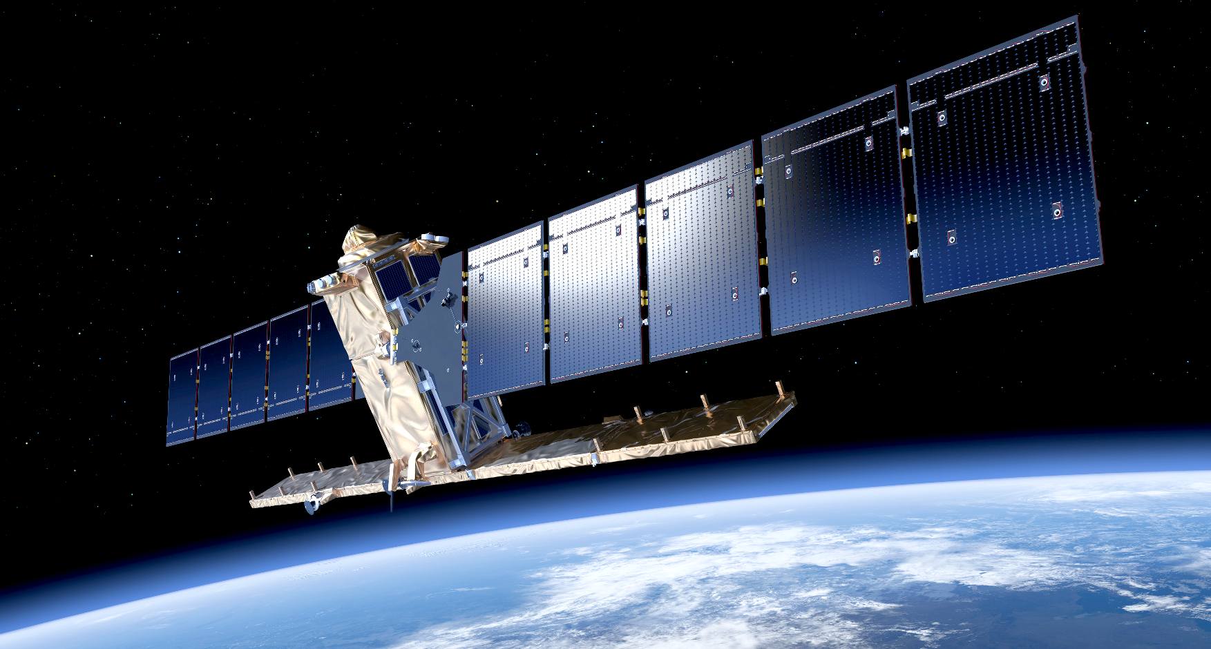
HORIZON
2020 - 25 November 2013, Countdown to the launch of the
first Copernicus satellite.
European Commission Vice-President Antonio Tajani has
announced the launch of Sentinel-1A, the first satellite of
the EU Copernicus Programme that will fly in outer space.
The launch is due to take place in April or May 2014 on a
SOYUZ rocket from Europe’s Spaceport in French Guiana. It
will provide continuous, systematic, highly reliable radar
imaging of the Earth. By using microwave frequencies, the
satellite can see through clouds and storms, acquiring imagery
regardless of the weather.
It will monitor sea ice and the Arctic environment, survey
marine oil spills, and detect ships in coastal zones for
maritime security. It will also spur the growth of the
observation service industry, contribute to climate
monitoring, and provide support in emergency and crisis
situations.
The benefits of an operational Copernicus programme through to
2030 are estimated at €30bn. The estimated downstream market
potential turnover attributable to Copernicus is expected to
be €1.8bn by 2030.
Sentinel-1A is a product of co-operation between several
partners. As with all the Sentinels, it is the European Space
Agency who has developed it, including its design and
procurement. The first Copernicus mission, Sentinel-1, is
composed of two polar-orbiting satellites known as Sentinel-1A
and Sentinel-1B. Sentinel-1B is expected to launch in late
2015.
COPERNICUS
PROGRAMME
Copernicus is the worlds largest single earth observation programme and directed by the
European Commission in partnership with the European Space Agency (ESA). It aims at achieving a global, continuous, autonomous, high quality, wide range Earth observation capacity. Providing accurate, timely and easily accessible information to, among other things, improve the management of the environment, understand and mitigate the effects of climate change, and ensure civil security. It follows and greatly expands on the work of the previous 2.3 billion euros European Envisat program which operated from 2002 to 2012.
Its cost during 1998 to 2020 are estimated at 6.7 billion euros with around €4.3bn spend in the period 2014 to 2020 and shared between the EU (66%) and ESA (33%) with benefits of the data to the EU economy estimated at roughly 30
billion
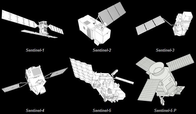
euros through 2030. ESA as a main partner has performed much of the design and oversees and co-funds the development of Sentinel mission 1, 2, 3, 4, 5 and 6 with each sentinel mission consisting of at least 2 satellites and some like sentinel 1 consisting of 4 satellites. They will also provide the instruments for MTG and MetOp-SG weather satellites of EUMETSAT where ESA and EUMETSAT will also coordinate the delivery of data from upwards of 30 satellites that form the contributing satellite missions to Copernicus.
The objective is to use multi-source data to get timely and quality information, services and knowledge, and to provide autonomous and independent access to information in relation to the environment and security on a global level. In other words, it will pull together all the information obtained by the Copernicus environmental satellites, air and ground stations to provide a comprehensive picture of the "health" of Earth. The geo-spatial information services offered by Copernicus can be grouped into six main interacting themes: land, ocean, emergency response, atmosphere, security and climate change. The first three Copernicus services under the land, ocean and emergency response themes and two additional services addressing the atmosphere and security themes were unveiled at the Copernicus Forum held in Lille in September 2008.
Copernicus builds upon three components:
1. the space component (observation satellites and associated ground segment with missions observing land, atmospheric and oceanographic parameters) This comprises two types of satellite missions, ESA's five families of dedicated Sentinel (space missions) and missions from other space agencies, called Contributing Missions.
2. in-situ measurements (ground-based and airborne data gathering networks providing information on oceans, continental surface and atmosphere)
3. services to users.
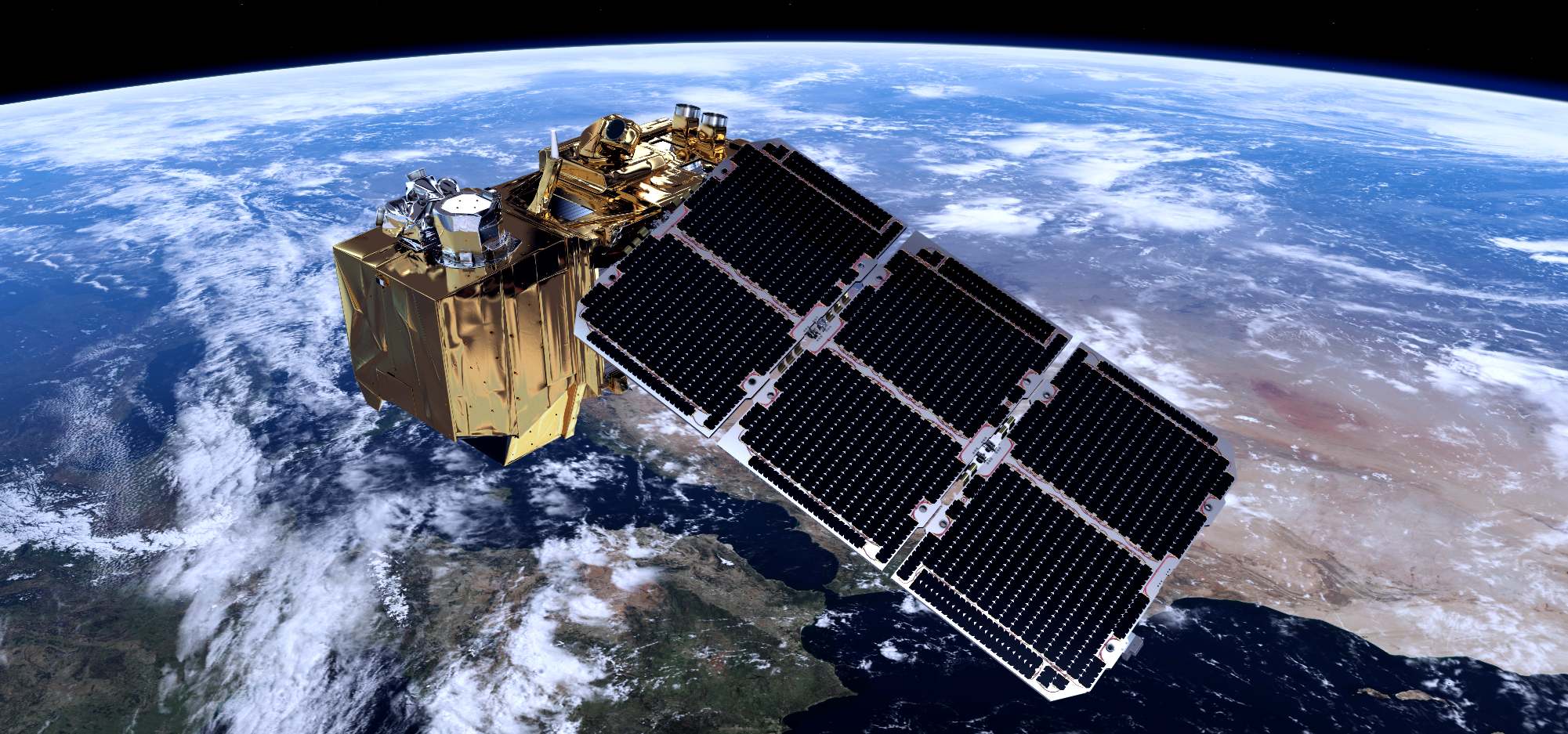
SATELLITE TODAY - December 5 2014,
The European Space Agency (ESA) has selected Airbus Defence and Space as the prime contractor for the Jason CS/Sentinel 6 Earth observation satellite. Thales Alenia Space France is providing the satellite’s main instrument, a radar altimeter that will measure global sea levels with accuracy within a few centimeters. NASA’s Jet Propulsion Laboratory (JPL) is also providing instruments.
The one-ton satellite will orbit at an altitude of 1,300 kilometers, repeatedly mapping ocean topography on a global basis starting in 2020. Eumetsat will manage the satellite, which is part of the Copernicus Earth observation program, for its five-and-a-half-year mission. Sentinel 6 will leverage technologies and skills gained from the CryoSat program, which also used a
radar altimeter on CryoSat 2, launched in 2010.
ABOUT
AIRBUS DEFENCE & SPACE
Airbus Defence and Space is a division of Airbus Group formed by combining the business activities of Cassidian, Astrium and Airbus Military. The division is Europe’s number one defence and space enterprise, the second largest space business worldwide and among the top ten global defence enterprises. It employs some 38,000 employees generating revenues of approximately €14 billion per year.
Airbus Press Contacts:
Astrid Emerit + 33 1 39 06 89 43 astrid.emerit@astrium.eads.net
Jeremy Close + 44 14 38 77 38 72 jeremy.close@astrium.eads.net
Gregory Gavroy + 33 1 39 06 89 42 gregory.gavroy@astrium.eads.net
Ralph Heinrich + 49 89 607 33971 ralph.heinrich@astrium.eads.net
Mathias Pikelj + 49 75 45 89 123 mathias.pikelj@astrium.eads.net
Francisco Lechón + 34 91 586 37 41 francisco.lechon@astrium.eads.net
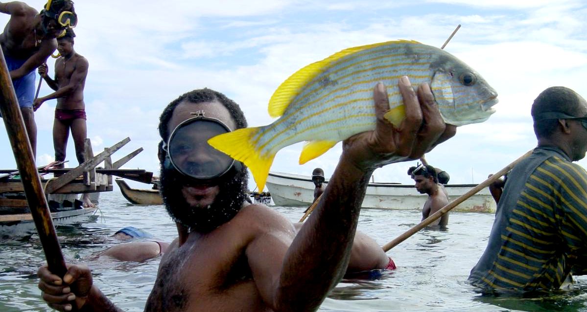
MARINE
MONITORING
The Copernicus Marine Monitoring Service makes use of satellite data to provide regular and systematic reference information about the state of the oceans and European seas, thereby supporting applications such as the protection and the sustainable management of living marine resources such as
aquaculture and fisheries.
As a rich and healthy source of protein, seafood plays a significant role in the
human diet, both in
Europe and worldwide. About 20% of the global population acquires at least 20% of their animal protein from fish. As the population continues to grow, more and more fish will be needed, putting further pressure on fishery production. Since the
fishing of many species at sea have already exceeded sustainable levels, this need can only be matched by expanding aquaculture. However, the effective and sustainable management of aquaculture sites is challenging and requires continuous monitoring of local conditions. This is not just to detect any potential hazards to the fish stocks, but also to ensure that production practices do not degrade ecosystems and endanger public health through, for example, the leakage of
waste products, foodstuffs, chemicals or parasites.
A wide range of satellite-based products and services can effectively support the planning and management of aquaculture practices. These include the delineation and tracking of possible hazards to aquaculture sites such as anomalies in sea-surface temperature and ocean colour, algal blooms, jellyfish invasions and the incursion of water masses with different temperatures or oxygen concentrations. Satellite data can also be used for the assessment of environmental changes in the vicinity of aquaculture sites by, for example, detecting changes in sea grass beds,
coral
reefs, mangrove forests, erosion or deposition on inter-tidal mud flats. The compilation of statistical information on local conditions can help optimise the selection of new sites for aquaculture. At the same time, local models can help forecast the spread of diseases and other contaminates from aquaculture facilities. This helps optimise the relocation of cages when an area is threatened with algal blooms and other hazardous situations.
MARINE
PROJECTS
AGRICULTURE FORESTRY AND FISHERIES
In the domain of agriculture, EU policies aim to foster the development of practices that preserve the environment and sustain productivity.
Copernicus helps to assess agricultural land use and trends and their impacts on biodiversity and landscapes. Copernicus can also help assess crop conditions and yield forecasts. Additionaly, it can help public authorities and farmers to improve irrigation management by monitoring agricultural pressure on water.
In the domain of forestry, Copernicus provides solutions to identify forest types, detect changes, map and monitor clear-cuts. It also assesses forest density and health. This can in particular, support users in their reporting obligations towards national and international policies (e.g.
UN Framework Convention on
Climate
Change).
Copernicus also contributes to the sustainable management of living marine resources. Thanks to its ability to monitor phytoplankton, algae, pollutants,
water temperature, etc. Copernicus can support efficient fishing operations, water pollution detection or help to identify the most favourable areas for installing
fish
farms.
CLIMATE AND ENERGY
The international community agrees that human reliance on burning fossil fuels for energy is considered to be one of the causes of global climate change, and on the other hand, we face a looming
energy crisis as the threat of peak
oil approaches.
By 2020, at least 20% of the energy supply in the EU should stem from renewable sources. Wind, a proven source of clean, affordable energy, will play a key role in reaching this binding target. The sun is also an amazing source of sustainable renewable energy: Deserts get more energy from the sun in one day than mankind consumes in one year.
Copernicus can support the efficient exploitation of these renewable energies, which will help to meet the growing global energy demands without increasing
CO2 emissions.
For instance, the Copernicus Marine Environment Monitoring Service provides information relevant to
offshore wind
farms, such as wind speed, wind fields and wave size and frequency. These parameters are crucial in determining where wind energy can be generated in the most cost-effective way whilst reducing the risks of damage.
Another example is the Copernicus Atmosphere Monitoring Service, which monitors the atmospheric conditions having an impact on the solar radiations that reach the Earth surface and provides the
solar energy sector and public authorities with suitable and accurate information for a better management of solar energy.

NICOLAUS
COPERNICUS
Nicolaus Copernicus (German: Nikolaus Kopernikus; 19 February 1473 – 24 May 1543) was a Renaissance mathematician and astronomer who formulated a model of the universe that placed
the Sun rather than the Earth at the center of the universe, likely independently of Aristarchus of Samos, who had formulated such a model some eighteen centuries earlier.
The publication of Copernicus' model in his book De revolutionibus orbium coelestium (On the Revolutions of the Celestial Spheres), just before his death in 1543, was a major event in the history of science, triggering the Copernican Revolution and making an important contribution to the Scientific Revolution.
Copernicus was born and died in Royal Prussia, a region that had been part of the Kingdom of
Poland since 1466. A polyglot and polymath, he obtained a doctorate in canon law and was also a mathematician, astronomer, physician, classics scholar, translator, governor, diplomat, and economist. In 1517 he derived a quantity theory of money – a key concept in economics – and in 1519 he formulated an economics principle that later came to be called Gresham's law.
DWINDLING
FISH STOCKS - Food
security is a major problem the world will have to face as
the available land for to grow crops reduces in competition
with land for housing, as the population expands. The
situation is far from sustainable and a bubble that will
burst. When the bubble bursts it will cause the deaths of
millions of people, where additional farming will create more
carbon dioxide to heat the climate, making more land barren in
a vicious circle that we must take steps to prevent happening.
Around
10% of the world (700,000,000 million people) rely on the
ocean for food, but in addition to our poor land management
record, we are also polluting the seven seas with plastic that
is toxic - so reducing the number of fish that we might
harvest for food. Satellites,
such as those of the European
Space Agency and the Copernicus
programme, might be used to find ocean waste with
further research and development.


LINKS
& REFERENCE
https://en.wikipedia.org/wiki/Copernicus_Programme
Food
watch from space - How satellites support agriculture (Source
ESA Briefs)
Monitoring
soil moisture for optimised irrigation planning (Source Window
on GMES)
Information
on forest structure and damages for sustainable forest
management (Source Window on GMES)
Satellites
support sustainable aquaculture development (Source ESA
Briefs)
Monitoring
Europe's green lungs (Source ESA Briefs)
Monitoring
toxical algal blooms (Source ESA Briefs)
Supporting
the monitoring of fish stocks and habitats (Source ESA Briefs) http://horizon2020projects.com/il-space/countdown-to-the-launch-of-the-first-copernicus-satellite/
http://www.satellitetoday.com/technology/2014/12/05/esa-awards-contracts-for-sentinel-6-satellite/
http://www.space-airbusds.com/en/press_centre/airbus-defence-and-space-and-copernicus.html
http://www.copernicus.eu/
https://sentinel.esa.int/web/sentinel/home
https://sentinels.copernicus.eu/web/sentinel/home
https://en.wikipedia.org/wiki/Nicolaus_Copernicus
This
website is copyright © Cleaner
Oceans Club Ltd (COCL) (Company No: 4674774)
January 2017
Solar
Studios, BN271RF, United Kingdom.
COCL
is a charity without share capital. The name Miss
Ocean™ is a
trade mark
of the Cleaner Oceans
Foundation™. The name SeaVax™,
is a trade
mark used under license. Site
Navigator
|